
Hurricane Melissa begins to turn towards Jamaica

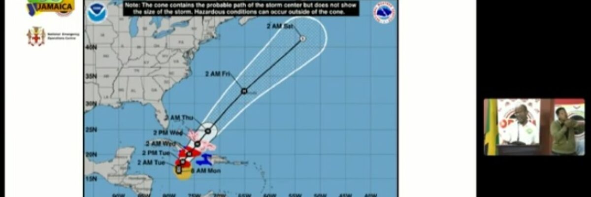
Powerful  Hurricane Melissa has begun to turn toward Jamaica, while  moving over the Caribbean sea south of the island.

A hurricane warning remains in effect for the country.

Tropical storm conditions are occurring over Jamaica and catastrophic hurricane-force wind conditions are expected to begin tonight and continue into Tuesday.

At 4:00 p.m., the centre of Hurricane Melissa was located near latitude 16.7 degrees north, 78.4 degrees west.

This is 225 kilometres (140 miles) southwest of Kingston, or 178 kilometres (111 miles) south of Negril point.

Melissa is moving toward the northwest near 6 km/h or 3 mph.

A slow turn toward the north is expected this evening,  followed by a turn toward the northeast and a faster forward speed on Tuesday.

On the forecast track, the core of  Melissa is expected to start moving over jamaica tonight and early Tuesday. 

Maximum sustained winds are near 280 km/h or 175 mph), with higher gusts.

Melissa is a category 5 hurricane on the Saffir-Simpson hurricane wind scale.

Some fluctuations in intensity are likely before melissa makes landfall on Jamaica,  as an extremely powerful major hurricane, on Tuesday.

Hurricane-force winds extend outward up to 45 km (30 miles) from the centre and tropical-storm-force winds extend outward  315 km (195 miles).

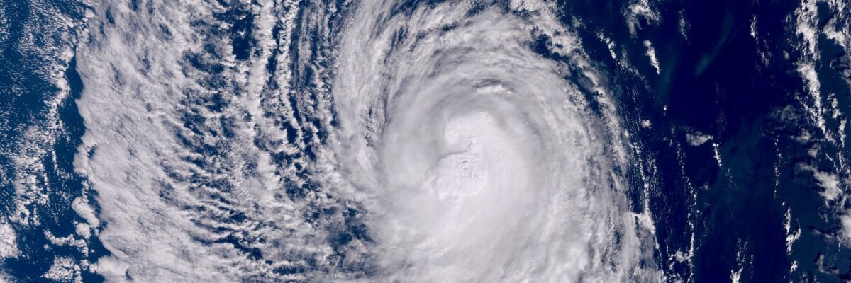
Doppler radar and satellite images show that outer bands of Hurricane Melissa have been producing periods of moderate to  heavy rainfall over mainly southern and western sections of Jamaica over the past few hours.

Hurricane Melissa is expected to produce rainfall amounts reaching 350-750 mm (15-30 inches) over parts of Jamaica in the  next couple of days, especially over central and eastern parishes, with higher amounts over hilly terrain.

Catastrophic flash floods and landslides are likely.

Tropical storm conditions are occurring over Jamaica, and catastrophic hurricane-force wind conditions are expected to   begin tonight and continue into Tuesday.

Life-threatening storm surge, accompanied by large and destructive waves, are  likely along the south coast of Jamaica  tonight and on Tuesday, peaking at 9 to 13 feet above ground level near and to the east of where the centre of melissa  makes landfall.

On the northwestern coast, there is the possibility of 1-3 foot storm surge above ground level.

Small craft operators, including fishers on the cays and banks, are reminded to remain in safe harbour until all warning  messages have been lifted and wind and sea conditions have returned to normal.

Read More

Government orders evacuation of 7 communities with immediate effect

Powerful  Hurricane Melissa has begun to turn toward Jamaica, while  moving over the Caribbean sea south of the island.

A hurricane warning remains in effect for the country.

Tropical storm conditions are occurring over Jamaica and catastrophic hurricane-force wind conditions are expected to begin tonight and continue into Tuesday.

At 4:00 p.m., the centre of Hurricane Melissa was located near latitude 16.7 degrees north, 78.4 degrees west.

This is 225 kilometres (140 miles) southwest of Kingston, or 178 kilometres (111 miles) south of Negril point.

Melissa is moving toward the northwest near 6 km/h or 3 mph.

A slow turn toward the north is expected this evening,  followed by a turn toward the northeast and a faster forward speed on Tuesday.

On the forecast track, the core of  Melissa is expected to start moving over jamaica tonight and early Tuesday. 

Maximum sustained winds are near 280 km/h or 175 mph), with higher gusts.

Melissa is a category 5 hurricane on the Saffir-Simpson hurricane wind scale.

Some fluctuations in intensity are likely before melissa makes landfall on Jamaica,  as an extremely powerful major hurricane, on Tuesday.

Hurricane-force winds extend outward up to 45 km (30 miles) from the centre and tropical-storm-force winds extend outward  315 km (195 miles).

Doppler radar and satellite images show that outer bands of Hurricane Melissa have been producing periods of moderate to  heavy rainfall over mainly southern and western sections of Jamaica over the past few hours.

Hurricane Melissa is expected to produce rainfall amounts reaching 350-750 mm (15-30 inches) over parts of Jamaica in the  next couple of days, especially over central and eastern parishes, with higher amounts over hilly terrain.

Catastrophic flash floods and landslides are likely.

Tropical storm conditions are occurring over Jamaica, and catastrophic hurricane-force wind conditions are expected to   begin tonight and continue into Tuesday.

Life-threatening storm surge, accompanied by large and destructive waves, are  likely along the south coast of Jamaica  tonight and on Tuesday, peaking at 9 to 13 feet above ground level near and to the east of where the centre of melissa  makes landfall.

On the northwestern coast, there is the possibility of 1-3 foot storm surge above ground level.

Small craft operators, including fishers on the cays and banks, are reminded to remain in safe harbour until all warning  messages have been lifted and wind and sea conditions have returned to normal.

Read More

Rural school buses to be used to facilitate movement of persons following evacuation order

Powerful  Hurricane Melissa has begun to turn toward Jamaica, while  moving over the Caribbean sea south of the island.

A hurricane warning remains in effect for the country.

Tropical storm conditions are occurring over Jamaica and catastrophic hurricane-force wind conditions are expected to begin tonight and continue into Tuesday.

At 4:00 p.m., the centre of Hurricane Melissa was located near latitude 16.7 degrees north, 78.4 degrees west.

This is 225 kilometres (140 miles) southwest of Kingston, or 178 kilometres (111 miles) south of Negril point.

Melissa is moving toward the northwest near 6 km/h or 3 mph.

A slow turn toward the north is expected this evening,  followed by a turn toward the northeast and a faster forward speed on Tuesday.

On the forecast track, the core of  Melissa is expected to start moving over jamaica tonight and early Tuesday. 

Maximum sustained winds are near 280 km/h or 175 mph), with higher gusts.

Melissa is a category 5 hurricane on the Saffir-Simpson hurricane wind scale.

Some fluctuations in intensity are likely before melissa makes landfall on Jamaica,  as an extremely powerful major hurricane, on Tuesday.

Hurricane-force winds extend outward up to 45 km (30 miles) from the centre and tropical-storm-force winds extend outward  315 km (195 miles).

Doppler radar and satellite images show that outer bands of Hurricane Melissa have been producing periods of moderate to  heavy rainfall over mainly southern and western sections of Jamaica over the past few hours.

Hurricane Melissa is expected to produce rainfall amounts reaching 350-750 mm (15-30 inches) over parts of Jamaica in the  next couple of days, especially over central and eastern parishes, with higher amounts over hilly terrain.

Catastrophic flash floods and landslides are likely.

Tropical storm conditions are occurring over Jamaica, and catastrophic hurricane-force wind conditions are expected to   begin tonight and continue into Tuesday.

Life-threatening storm surge, accompanied by large and destructive waves, are  likely along the south coast of Jamaica  tonight and on Tuesday, peaking at 9 to 13 feet above ground level near and to the east of where the centre of melissa  makes landfall.

On the northwestern coast, there is the possibility of 1-3 foot storm surge above ground level.

Small craft operators, including fishers on the cays and banks, are reminded to remain in safe harbour until all warning  messages have been lifted and wind and sea conditions have returned to normal.
Read More

Hurricane warning remains in effect for Jamaica as Melissa intensifies

Powerful  Hurricane Melissa has begun to turn toward Jamaica, while  moving over the Caribbean sea south of the island.

A hurricane warning remains in effect for the country.

Tropical storm conditions are occurring over Jamaica and catastrophic hurricane-force wind conditions are expected to begin tonight and continue into Tuesday.

At 4:00 p.m., the centre of Hurricane Melissa was located near latitude 16.7 degrees north, 78.4 degrees west.

This is 225 kilometres (140 miles) southwest of Kingston, or 178 kilometres (111 miles) south of Negril point.

Melissa is moving toward the northwest near 6 km/h or 3 mph.

A slow turn toward the north is expected this evening,  followed by a turn toward the northeast and a faster forward speed on Tuesday.

On the forecast track, the core of  Melissa is expected to start moving over jamaica tonight and early Tuesday. 

Maximum sustained winds are near 280 km/h or 175 mph), with higher gusts.

Melissa is a category 5 hurricane on the Saffir-Simpson hurricane wind scale.

Some fluctuations in intensity are likely before melissa makes landfall on Jamaica,  as an extremely powerful major hurricane, on Tuesday.

Hurricane-force winds extend outward up to 45 km (30 miles) from the centre and tropical-storm-force winds extend outward  315 km (195 miles).

Doppler radar and satellite images show that outer bands of Hurricane Melissa have been producing periods of moderate to  heavy rainfall over mainly southern and western sections of Jamaica over the past few hours.

Hurricane Melissa is expected to produce rainfall amounts reaching 350-750 mm (15-30 inches) over parts of Jamaica in the  next couple of days, especially over central and eastern parishes, with higher amounts over hilly terrain.

Catastrophic flash floods and landslides are likely.

Tropical storm conditions are occurring over Jamaica, and catastrophic hurricane-force wind conditions are expected to   begin tonight and continue into Tuesday.

Life-threatening storm surge, accompanied by large and destructive waves, are  likely along the south coast of Jamaica  tonight and on Tuesday, peaking at 9 to 13 feet above ground level near and to the east of where the centre of melissa  makes landfall.

On the northwestern coast, there is the possibility of 1-3 foot storm surge above ground level.

Small craft operators, including fishers on the cays and banks, are reminded to remain in safe harbour until all warning  messages have been lifted and wind and sea conditions have returned to normal.

Read More

Some Jamaicans remain skeptical about TS Melissa others prepare

Powerful  Hurricane Melissa has begun to turn toward Jamaica, while  moving over the Caribbean sea south of the island.

A hurricane warning remains in effect for the country.

Tropical storm conditions are occurring over Jamaica and catastrophic hurricane-force wind conditions are expected to begin tonight and continue into Tuesday.

At 4:00 p.m., the centre of Hurricane Melissa was located near latitude 16.7 degrees north, 78.4 degrees west.

This is 225 kilometres (140 miles) southwest of Kingston, or 178 kilometres (111 miles) south of Negril point.

Melissa is moving toward the northwest near 6 km/h or 3 mph.

A slow turn toward the north is expected this evening,  followed by a turn toward the northeast and a faster forward speed on Tuesday.

On the forecast track, the core of  Melissa is expected to start moving over jamaica tonight and early Tuesday. 

Maximum sustained winds are near 280 km/h or 175 mph), with higher gusts.

Melissa is a category 5 hurricane on the Saffir-Simpson hurricane wind scale.

Some fluctuations in intensity are likely before melissa makes landfall on Jamaica,  as an extremely powerful major hurricane, on Tuesday.

Hurricane-force winds extend outward up to 45 km (30 miles) from the centre and tropical-storm-force winds extend outward  315 km (195 miles).

Doppler radar and satellite images show that outer bands of Hurricane Melissa have been producing periods of moderate to  heavy rainfall over mainly southern and western sections of Jamaica over the past few hours.

Hurricane Melissa is expected to produce rainfall amounts reaching 350-750 mm (15-30 inches) over parts of Jamaica in the  next couple of days, especially over central and eastern parishes, with higher amounts over hilly terrain.

Catastrophic flash floods and landslides are likely.

Tropical storm conditions are occurring over Jamaica, and catastrophic hurricane-force wind conditions are expected to   begin tonight and continue into Tuesday.

Life-threatening storm surge, accompanied by large and destructive waves, are  likely along the south coast of Jamaica  tonight and on Tuesday, peaking at 9 to 13 feet above ground level near and to the east of where the centre of melissa  makes landfall.

On the northwestern coast, there is the possibility of 1-3 foot storm surge above ground level.

Small craft operators, including fishers on the cays and banks, are reminded to remain in safe harbour until all warning  messages have been lifted and wind and sea conditions have returned to normal.

Read More

All schools to remain in remote learning mode tomorrow as Tropical Storm Melissa continues its approach

Powerful  Hurricane Melissa has begun to turn toward Jamaica, while  moving over the Caribbean sea south of the island.

A hurricane warning remains in effect for the country.

Tropical storm conditions are occurring over Jamaica and catastrophic hurricane-force wind conditions are expected to begin tonight and continue into Tuesday.

At 4:00 p.m., the centre of Hurricane Melissa was located near latitude 16.7 degrees north, 78.4 degrees west.

This is 225 kilometres (140 miles) southwest of Kingston, or 178 kilometres (111 miles) south of Negril point.

Melissa is moving toward the northwest near 6 km/h or 3 mph.

A slow turn toward the north is expected this evening,  followed by a turn toward the northeast and a faster forward speed on Tuesday.

On the forecast track, the core of  Melissa is expected to start moving over jamaica tonight and early Tuesday. 

Maximum sustained winds are near 280 km/h or 175 mph), with higher gusts.

Melissa is a category 5 hurricane on the Saffir-Simpson hurricane wind scale.

Some fluctuations in intensity are likely before melissa makes landfall on Jamaica,  as an extremely powerful major hurricane, on Tuesday.

Hurricane-force winds extend outward up to 45 km (30 miles) from the centre and tropical-storm-force winds extend outward  315 km (195 miles).

Doppler radar and satellite images show that outer bands of Hurricane Melissa have been producing periods of moderate to  heavy rainfall over mainly southern and western sections of Jamaica over the past few hours.

Hurricane Melissa is expected to produce rainfall amounts reaching 350-750 mm (15-30 inches) over parts of Jamaica in the  next couple of days, especially over central and eastern parishes, with higher amounts over hilly terrain.

Catastrophic flash floods and landslides are likely.

Tropical storm conditions are occurring over Jamaica, and catastrophic hurricane-force wind conditions are expected to   begin tonight and continue into Tuesday.

Life-threatening storm surge, accompanied by large and destructive waves, are  likely along the south coast of Jamaica  tonight and on Tuesday, peaking at 9 to 13 feet above ground level near and to the east of where the centre of melissa  makes landfall.

On the northwestern coast, there is the possibility of 1-3 foot storm surge above ground level.

Small craft operators, including fishers on the cays and banks, are reminded to remain in safe harbour until all warning  messages have been lifted and wind and sea conditions have returned to normal.

Read More

JPS says Jamaicans should plan for outages during Melissa’s passage

Powerful  Hurricane Melissa has begun to turn toward Jamaica, while  moving over the Caribbean sea south of the island.

A hurricane warning remains in effect for the country.

Tropical storm conditions are occurring over Jamaica and catastrophic hurricane-force wind conditions are expected to begin tonight and continue into Tuesday.

At 4:00 p.m., the centre of Hurricane Melissa was located near latitude 16.7 degrees north, 78.4 degrees west.

This is 225 kilometres (140 miles) southwest of Kingston, or 178 kilometres (111 miles) south of Negril point.

Melissa is moving toward the northwest near 6 km/h or 3 mph.

A slow turn toward the north is expected this evening,  followed by a turn toward the northeast and a faster forward speed on Tuesday.

On the forecast track, the core of  Melissa is expected to start moving over jamaica tonight and early Tuesday. 

Maximum sustained winds are near 280 km/h or 175 mph), with higher gusts.

Melissa is a category 5 hurricane on the Saffir-Simpson hurricane wind scale.

Some fluctuations in intensity are likely before melissa makes landfall on Jamaica,  as an extremely powerful major hurricane, on Tuesday.

Hurricane-force winds extend outward up to 45 km (30 miles) from the centre and tropical-storm-force winds extend outward  315 km (195 miles).

Doppler radar and satellite images show that outer bands of Hurricane Melissa have been producing periods of moderate to  heavy rainfall over mainly southern and western sections of Jamaica over the past few hours.

Hurricane Melissa is expected to produce rainfall amounts reaching 350-750 mm (15-30 inches) over parts of Jamaica in the  next couple of days, especially over central and eastern parishes, with higher amounts over hilly terrain.

Catastrophic flash floods and landslides are likely.

Tropical storm conditions are occurring over Jamaica, and catastrophic hurricane-force wind conditions are expected to   begin tonight and continue into Tuesday.

Life-threatening storm surge, accompanied by large and destructive waves, are  likely along the south coast of Jamaica  tonight and on Tuesday, peaking at 9 to 13 feet above ground level near and to the east of where the centre of melissa  makes landfall.

On the northwestern coast, there is the possibility of 1-3 foot storm surge above ground level.

Small craft operators, including fishers on the cays and banks, are reminded to remain in safe harbour until all warning  messages have been lifted and wind and sea conditions have returned to normal.
Read More

$200M drain cleaning programme activated spanning parishes from eastern Jamaica to St. Elizabeth

Powerful  Hurricane Melissa has begun to turn toward Jamaica, while  moving over the Caribbean sea south of the island.

A hurricane warning remains in effect for the country.

Tropical storm conditions are occurring over Jamaica and catastrophic hurricane-force wind conditions are expected to begin tonight and continue into Tuesday.

At 4:00 p.m., the centre of Hurricane Melissa was located near latitude 16.7 degrees north, 78.4 degrees west.

This is 225 kilometres (140 miles) southwest of Kingston, or 178 kilometres (111 miles) south of Negril point.

Melissa is moving toward the northwest near 6 km/h or 3 mph.

A slow turn toward the north is expected this evening,  followed by a turn toward the northeast and a faster forward speed on Tuesday.

On the forecast track, the core of  Melissa is expected to start moving over jamaica tonight and early Tuesday. 

Maximum sustained winds are near 280 km/h or 175 mph), with higher gusts.

Melissa is a category 5 hurricane on the Saffir-Simpson hurricane wind scale.

Some fluctuations in intensity are likely before melissa makes landfall on Jamaica,  as an extremely powerful major hurricane, on Tuesday.

Hurricane-force winds extend outward up to 45 km (30 miles) from the centre and tropical-storm-force winds extend outward  315 km (195 miles).

Doppler radar and satellite images show that outer bands of Hurricane Melissa have been producing periods of moderate to  heavy rainfall over mainly southern and western sections of Jamaica over the past few hours.

Hurricane Melissa is expected to produce rainfall amounts reaching 350-750 mm (15-30 inches) over parts of Jamaica in the  next couple of days, especially over central and eastern parishes, with higher amounts over hilly terrain.

Catastrophic flash floods and landslides are likely.

Tropical storm conditions are occurring over Jamaica, and catastrophic hurricane-force wind conditions are expected to   begin tonight and continue into Tuesday.

Life-threatening storm surge, accompanied by large and destructive waves, are  likely along the south coast of Jamaica  tonight and on Tuesday, peaking at 9 to 13 feet above ground level near and to the east of where the centre of melissa  makes landfall.

On the northwestern coast, there is the possibility of 1-3 foot storm surge above ground level.

Small craft operators, including fishers on the cays and banks, are reminded to remain in safe harbour until all warning  messages have been lifted and wind and sea conditions have returned to normal.

Read More

Local authorities on alert as they pay close attention to weather over the coming days

Powerful  Hurricane Melissa has begun to turn toward Jamaica, while  moving over the Caribbean sea south of the island.

A hurricane warning remains in effect for the country.

Tropical storm conditions are occurring over Jamaica and catastrophic hurricane-force wind conditions are expected to begin tonight and continue into Tuesday.

At 4:00 p.m., the centre of Hurricane Melissa was located near latitude 16.7 degrees north, 78.4 degrees west.

This is 225 kilometres (140 miles) southwest of Kingston, or 178 kilometres (111 miles) south of Negril point.

Melissa is moving toward the northwest near 6 km/h or 3 mph.

A slow turn toward the north is expected this evening,  followed by a turn toward the northeast and a faster forward speed on Tuesday.

On the forecast track, the core of  Melissa is expected to start moving over jamaica tonight and early Tuesday. 

Maximum sustained winds are near 280 km/h or 175 mph), with higher gusts.

Melissa is a category 5 hurricane on the Saffir-Simpson hurricane wind scale.

Some fluctuations in intensity are likely before melissa makes landfall on Jamaica,  as an extremely powerful major hurricane, on Tuesday.

Hurricane-force winds extend outward up to 45 km (30 miles) from the centre and tropical-storm-force winds extend outward  315 km (195 miles).

Doppler radar and satellite images show that outer bands of Hurricane Melissa have been producing periods of moderate to  heavy rainfall over mainly southern and western sections of Jamaica over the past few hours.

Hurricane Melissa is expected to produce rainfall amounts reaching 350-750 mm (15-30 inches) over parts of Jamaica in the  next couple of days, especially over central and eastern parishes, with higher amounts over hilly terrain.

Catastrophic flash floods and landslides are likely.

Tropical storm conditions are occurring over Jamaica, and catastrophic hurricane-force wind conditions are expected to   begin tonight and continue into Tuesday.

Life-threatening storm surge, accompanied by large and destructive waves, are  likely along the south coast of Jamaica  tonight and on Tuesday, peaking at 9 to 13 feet above ground level near and to the east of where the centre of melissa  makes landfall.

On the northwestern coast, there is the possibility of 1-3 foot storm surge above ground level.

Small craft operators, including fishers on the cays and banks, are reminded to remain in safe harbour until all warning  messages have been lifted and wind and sea conditions have returned to normal.

Read More

Jamaica under severe weather alert

Powerful  Hurricane Melissa has begun to turn toward Jamaica, while  moving over the Caribbean sea south of the island.

A hurricane warning remains in effect for the country.

Tropical storm conditions are occurring over Jamaica and catastrophic hurricane-force wind conditions are expected to begin tonight and continue into Tuesday.

At 4:00 p.m., the centre of Hurricane Melissa was located near latitude 16.7 degrees north, 78.4 degrees west.

This is 225 kilometres (140 miles) southwest of Kingston, or 178 kilometres (111 miles) south of Negril point.

Melissa is moving toward the northwest near 6 km/h or 3 mph.

A slow turn toward the north is expected this evening,  followed by a turn toward the northeast and a faster forward speed on Tuesday.

On the forecast track, the core of  Melissa is expected to start moving over jamaica tonight and early Tuesday. 

Maximum sustained winds are near 280 km/h or 175 mph), with higher gusts.

Melissa is a category 5 hurricane on the Saffir-Simpson hurricane wind scale.

Some fluctuations in intensity are likely before melissa makes landfall on Jamaica,  as an extremely powerful major hurricane, on Tuesday.

Hurricane-force winds extend outward up to 45 km (30 miles) from the centre and tropical-storm-force winds extend outward  315 km (195 miles).

Doppler radar and satellite images show that outer bands of Hurricane Melissa have been producing periods of moderate to  heavy rainfall over mainly southern and western sections of Jamaica over the past few hours.

Hurricane Melissa is expected to produce rainfall amounts reaching 350-750 mm (15-30 inches) over parts of Jamaica in the  next couple of days, especially over central and eastern parishes, with higher amounts over hilly terrain.

Catastrophic flash floods and landslides are likely.

Tropical storm conditions are occurring over Jamaica, and catastrophic hurricane-force wind conditions are expected to   begin tonight and continue into Tuesday.

Life-threatening storm surge, accompanied by large and destructive waves, are  likely along the south coast of Jamaica  tonight and on Tuesday, peaking at 9 to 13 feet above ground level near and to the east of where the centre of melissa  makes landfall.

On the northwestern coast, there is the possibility of 1-3 foot storm surge above ground level.

Small craft operators, including fishers on the cays and banks, are reminded to remain in safe harbour until all warning  messages have been lifted and wind and sea conditions have returned to normal.

Read More